
Stories of the Stars: Rigel. Artwork by Frank Paul.

I am working on a series of commercial poster-sized starmaps.
Here is a quick index of starmaps at this site, plus a few from elsewhere on the net.
Winchell's Starmap Posters
By popular demand I am using the power of Cafe Press to make available reasonably priced poster sized versions of my star maps. The largest are 23" x 35", the smallest will probably be 11" x 17".

30 Light Years

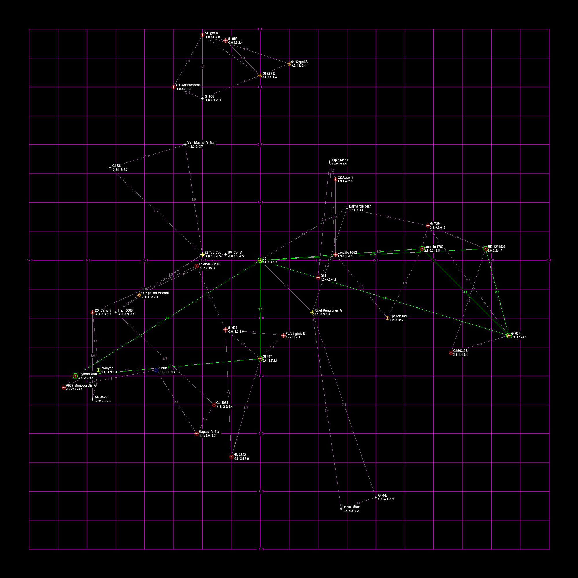
The first is a map of all known stars within 30 light-years of the Sun. This map is intended for SF authors plotting out their SF universes. The map comes in a full sized 23" x 35" poster, a small size 16” X 20” poster. The small size poster lacks the tables.
It is a Cartesian plot with the x-y plane parallel to the plane of the galaxy. The positive X-axis points at the galactic center ("Coreward"), the negative X-axis points at the galactic rim ("Rimward"), the positive Y-axis points in the direction of galactic rotation ("Spinward"), the negative Y-axis points opposite to the galactic rotation ("Trailing").
Distances are in light-years. Stars are indicated by an icon color coded to the spectral class of the star (or the brightest star if it is a multiple star system). Stars listed in the HabCat database have a high probability of possessing a human habitable planet and are marked with a green ring.
Stars are labeled with the name of all stars in the system and with the x,y,z Cartesian coordinates. Overlapping star icons are moved slightly for clarity, but the Cartesian coordinates are accurate.
Dotted lines are drawn between each star and its two closest neighbors, and the lines are labeled with the distance. In addition, HabCat stars have lines to their two closest HabCat stars.
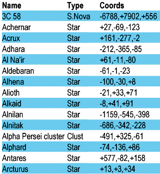
In the bottom part of the poster is a table of all the stars on the map. The table includes the star name, HabCat status, spectral class, and Cartesian coordinates.
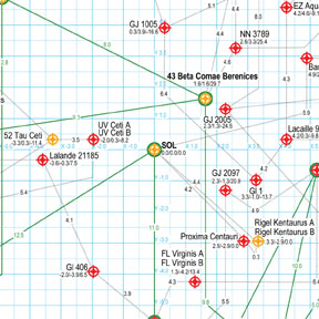
Image of the poster at 72 DPI, approximately the size it will appear on the 23” X 35” map. 
Image of the poster at 300 DPI, which demonstrates how crisp the detail will appear. 
Close up of the star table.

20 Light Year Hex Map

This is a map of all known stars within 20 light-years of the Sun. The map is plotted on a hex grid, suitable for playing war games. The map is similar to the one found in the out-of-print wargame StarForce. The map comes in a full sized 23" x 35" poster, and a small size 16” X 20” poster. The hexes on the full size map are large enough to accommodate a standard wargame playing counter. The other has hexes that are too small, but can be used as campaign planning maps.
Distances are in light-years. Each hexagon is one light-year in diameter. The map is spherical, so the various ring-shaped regions are labeled with the maximum height or depth values that will still be within the spherical boarder.
Stars are indicated by an icon color coded to the spectral class of the star (or the brightest star if it is a multiple star system). Stars listed in the HabCat database have a high probability of possessing a human habitable planet and are marked with a green ring.
Stars are labeled with the name of the brightest star in the system and with the height or depth from the surface of the map.
Dotted lines are drawn between each star and its two closest neighbors, and the lines are labeled with the distance. The hexagons the lines enter are immaterial. The lines should be straight but are artistically bent to flow along hexagonal lines in the name of clarity.
In the bottom part of the poster, to the left, is a table of all the stars on the map. The table includes the star name, HabCat status, spectral class, and Cartesian coordinates.
To the right is a True Distance table, used to calculate the actual three dimensional distance between any two points. Cross reference the horizontal distance between the two points in hexagons with the vertical distance on the table to find the actual distance. Distances too far to fit inside the spherical bounds of the map are marked in bold print.
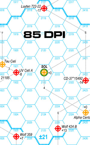
Image of poster at 85 DPI, approximately the size it will appear on the full sized map. Hexes are 16 mm high (0.63 inches). 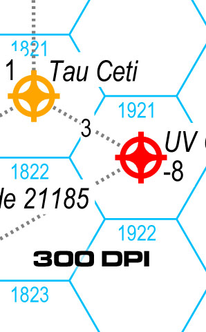
Image of the poster at 300 DPI, which demonstrates how crisp the detail will appear. 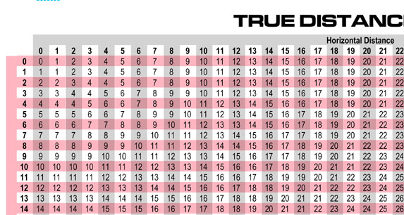
Close up of the True Distance table.
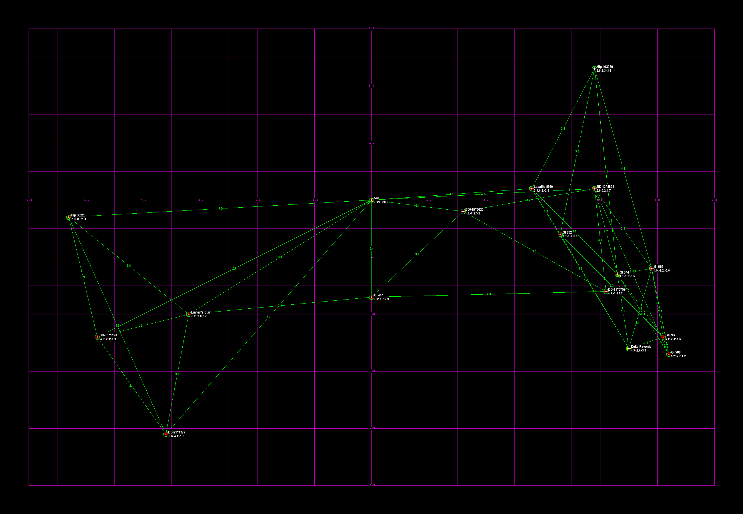
100 Nearest Stars
This is a map of the 100 nearest stars to the Sun, according to the RECONS dataset. The map comes in a full sized 23" x 35" poster, and a small size 16” X 20” poster.
It is a Cartesian plot with the x-y plane parallel to the plane of the galaxy. The positive X-axis points at the galactic center ("Coreward"), the negative X-axis points at the galactic rim ("Rimward"), the positive Y-axis points in the direction of galactic rotation ("Spinward"), the negative Y-axis points opposite to the galactic rotation ("Trailing").
Distances are in light-years. Stars are indicated by an icon color coded to the spectral class of the star (or the brightest star if it is a multiple star system). Stars listed in the HabCat database have a high probability of possessing a human habitable planet and are marked with a gold ring.
Stars are labeled with the name of all stars in the system and with the x,y,z Cartesian coordinates. Overlapping star icons are moved slightly for clarity, but the Cartesian coordinates are accurate.
Violet lines are drawn between each star and its two closest neighbors, and the lines are labeled with the distance. In addition, HabCat stars have green lines to their two closest HabCat stars.

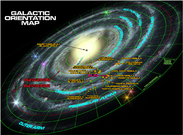
In the bottom part of the poster is a table of all the stars on the map. The table includes the star name, HabCat status, spectral class, and Cartesian coordinates. On the right side is a simple map of the galaxy, to provide orientation.
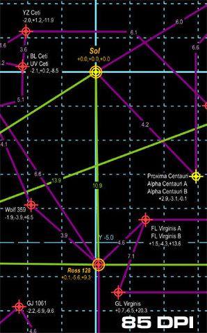
Image of the Cartesian plot at 85 DPI, approximately the size it will appear on the full sized map. 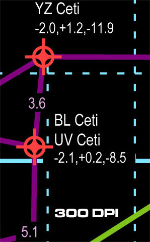
Image of the Cartesian plot at 300 DPI, which demonstrates how crisp the detail will appear.
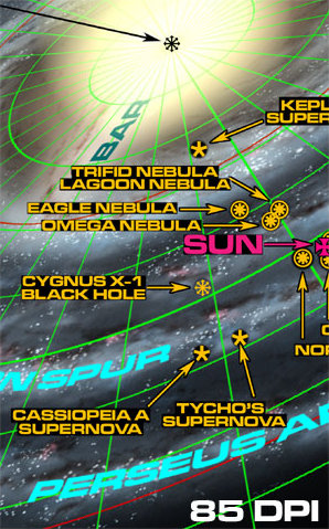
Image of the orientation map at 85 DPI, approximately the size it will appear on the full sized map. 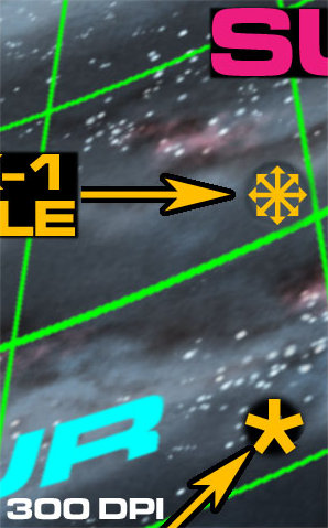
Image of the orientation map at 300 DPI, which demonstrates how crisp the detail will appear.
Galactic Map 2.0

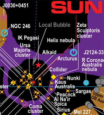
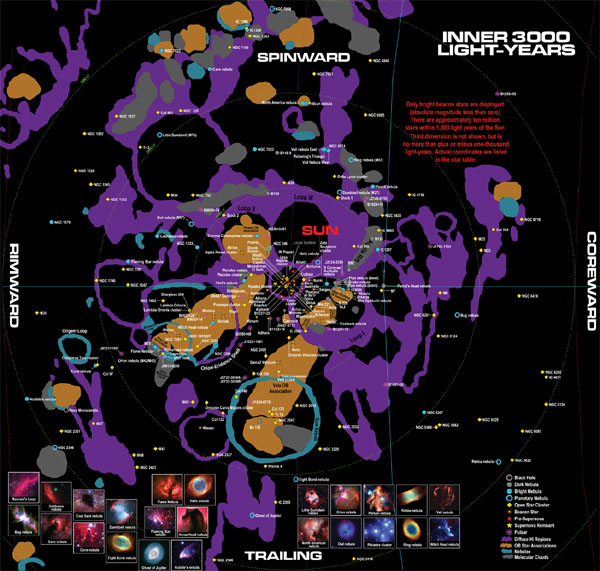
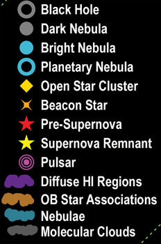
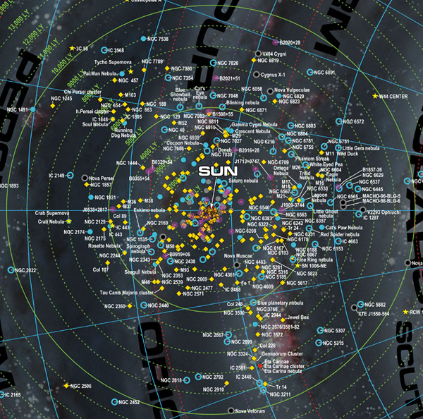
This a map of the entire Milky Way Galaxy, or at least the rimward half of it at any rate. It displays the locations of the spiral arms, suspected black holes, major dark/bright/planetary nebulae, open star clusters, bright beacon stars, supernova remnants, pre-supernovae, and pulsars.
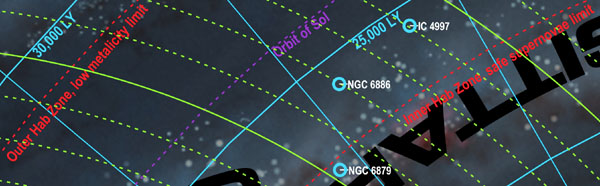
It is a Cartesian plot with the x-y plane parallel to the plane of the galaxy. The positive X-axis points at the galactic center ("Coreward"), the negative X-axis points at the galactic rim ("Rimward"), the positive Y-axis points in the direction of galactic rotation ("Spinward"), the negative Y-axis points opposite to the galactic rotation ("Trailing"). Distances are in light-years. The sources of the astronomical data used to create the map are listed. Distances from the galactic core are displayed in blue, distances from the sun are displayed in green.
The map is in four sections. The upper section charts the galaxy from the galactic core almost to the rim (about 45,000 light-years). The lower left section zooms into the area within 3,000 light-years of the sun. The upper part of the lower right section has a rough "orientation map" of the entire galaxy, similar to the one in the RECONS map. And the lower part of the lower right section has a table of all the objects on the map, a list of astronomical sources used, and a few notes.
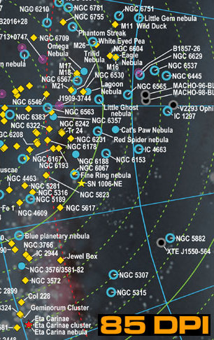
Image of the map at 85 DPI, approximately the size it will appear on the full sized map. 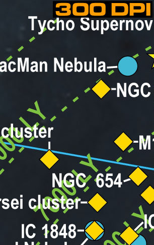
Image of the map at 300 DPI, which demonstrates how crisp the detail will appear. 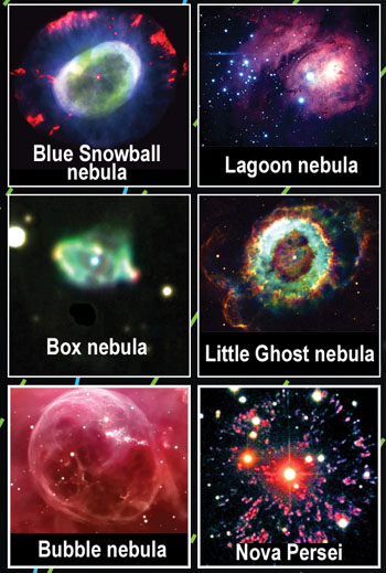
Sources for astronomical data:
- The Guide To The Galaxy, Henbest & Couper, Cambridge 1994, ISBN 0-521-45882-X
- J. Kormendy and K. Gebhardt (2001) [arXiv:astro-ph/0105230v1]
- J. Orosz (2002) [arXiv:astro-ph/0209041v1]
- S. Tremaine et ali (2002), Astrophysical Journal, 574:740-753
- J. Ziolkowski (2003) [arXiv:astro-ph/0307307v1]
- ATNF Pulsar Catalogue Manchester, R. N., Hobbs, G. B., Teoh, A. & Hobbs, M., AJ, 129, 1993-2006 (2005)
- Chandra Supernova Remnant Catalog
- An Atlas of the Universe
- Cosmobrain 50 Brightest Star Catalog
- Charles H. Lineweaver, Yeshe Finner and Brad K. Gibson (January 2004). "The Galactic Habitable Zone and the Age Distribution of Complex Life in the Milky Way". Science 303 Issue 5654: 59-62
- Gonzalez, Donald Brownlee and Peter D. Ward, “Refugees for Life in a Hostile Universe”, Scientific American, October, 2001
In some cases distance data was tweaked when different catalogs assigned inconsistent distances to objects that are actually associated.
"Beacon” stars are bright stars with absolute magnitudes of zero or less.
“Pre-supernova” stars are commonly believed by astronomers to be on the verge of exploding Real Soon Now (i.e., anytime from one million years from now to tomorrow).
“Collider” is Gliese 710. There is a fair chance it will collide with our solar system in approximately 1.4 million years, or at least pass by close enough to initiate a deadly hail of comets.
The “local bubble” is an area of reduced density in the interstellar medium, which is bad news for Bussard Ramjet spacecraft. It was probably created by the detonation of the SN437 Geminga supernova.
Only the Sunward half of the galaxy was plotted due to a lack of data for objects on the far side.
Blue lines measure angles and distances from the galactic core. Green lines measure distances from the Sun.
Red lines delineate the controversial “Galactic Habitable Zones. ”Red lines for “low metalicity limit” and “safe supernova limit” are from Lineweaver et al, other red lines are from Gonzalez et al.
Distances are in light-years instead of parsecs, which will please science fiction writers and annoy astronomers.
Grid and astronomical objects were plotted by a Python program using the Report Lab library, orientation map was created with the Blender 3D modeling package.
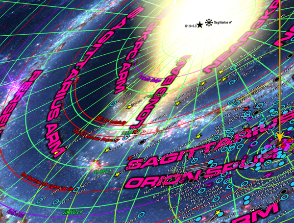
Galactic Map 3.0

click for larger image

This a map of the entire Milky Way Galaxy. It displays the locations of the spiral arms, suspected black holes, major dark/bright/planetary nebulae, supernova remnants, pre-supernovae, and pulsars. Unlike Galactic Map 2.0, this map is intended to be more a dramatic poster to decorate your wall rather than to be a practical map. The plane of the galaxy is skewed at a jaunty angle, garish colors are used, and by showing the entire galaxy it also makes an unseemly pile of astronomical objects within one thousand years of the Sun.
But it does look most magnificent! Stand in front of it while wearing your Galactic Emperor costume, strike a location on the map with your swagger stick, and announce "Tomorrow we strike { thwak!! } THERE!"
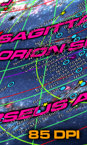
Image of the map at 85 DPI, approximately the size it will appear on the full sized map. 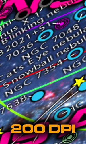
Image of the map at 200 DPI, which demonstrates how crisp the detail will appear. 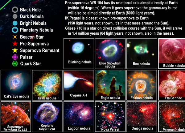
Sources for astronomical data:
- The Guide To The Galaxy, Henbest & Couper, Cambridge 1994, ISBN 0-521-45882-X
- J. Kormendy and K. Gebhardt (2001) [arXiv:astro-ph/0105230v1]
- J. Orosz (2002) [arXiv:astro-ph/0209041v1]
- S. Tremaine et ali (2002), Astrophysical Journal, 574:740-753
- J. Ziolkowski (2003) [arXiv:astro-ph/0307307v1]
- ATNF Pulsar Catalogue Manchester, R. N., Hobbs, G. B., Teoh, A. & Hobbs, M., AJ, 129, 1993-2006 (2005)
- Chandra Supernova Remnant Catalog
- An Atlas of the Universe
- Cosmobrain 50 Brightest Star Catalog
- Charles H. Lineweaver, Yeshe Finner and Brad K. Gibson (January 2004). "The Galactic Habitable Zone and the Age Distribution of Complex Life in the Milky Way". Science 303 Issue 5654: 59-62
- Gonzalez, Donald Brownlee and Peter D. Ward, “Refugees for Life in a Hostile Universe”, Scientific American, October, 2001
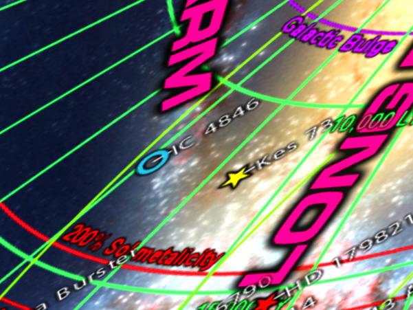
- Green lines measure angles and distances from the galactic core. Yellow-green lines measure distance from the Sun.
- Red lines delineate the controversial “Galactic Habitable Zones.” Red lines for “low metalicity limit” and “safe supernovae limit” are from Lineweaver et al, other red lines are from Gonzalez et al.
- Globular Clusters are omitted, since unlike the other objects they are far from the plane of the map.
- Distances are in light-years instead of parsecs, which will please science fiction writers and annoy astronomers.
- Spiral arm background image courtesy NASA/JPL-CalTec, artwork by Robert Hurt.
- Astronomical objects were plotted with a custom Python program, galaxy image was rendered with Blender 3D.
- Sagittarius A* is the supermassive black hole at the center of the galaxy.
- G1.9+03 is the most recent known supernova (~140 years old, plus timelag to galactic core).
- Pre-supernova VY Canis Majoris is the largest known star (~1800–2200 solar radii, 4900 light years).
- HE1327-2326 is the oldest known star (~13.6 billion years old, 4000 light years, near 3000 ly ring due to height).
- EGG M16-E42 (in the Eagle Nebula) is the youngest known star (~6000 years old, 5700 light years).
- Pre-supernova WR 104 has its rotational axis aimed directly at Earth (within 16 degrees). When it goes supernova the gamma-ray burst will also be aimed directly at Earth (8000 light years).
- IK Pegasi is closest known pre-supernova to Earth(150 light years, not shown, it’s in that mess around the Sun).
- Gliese 710 is a star on direct collision course with the Sun, it will arrive in 1.4 million years (64 light years, not shown, also in the mess).
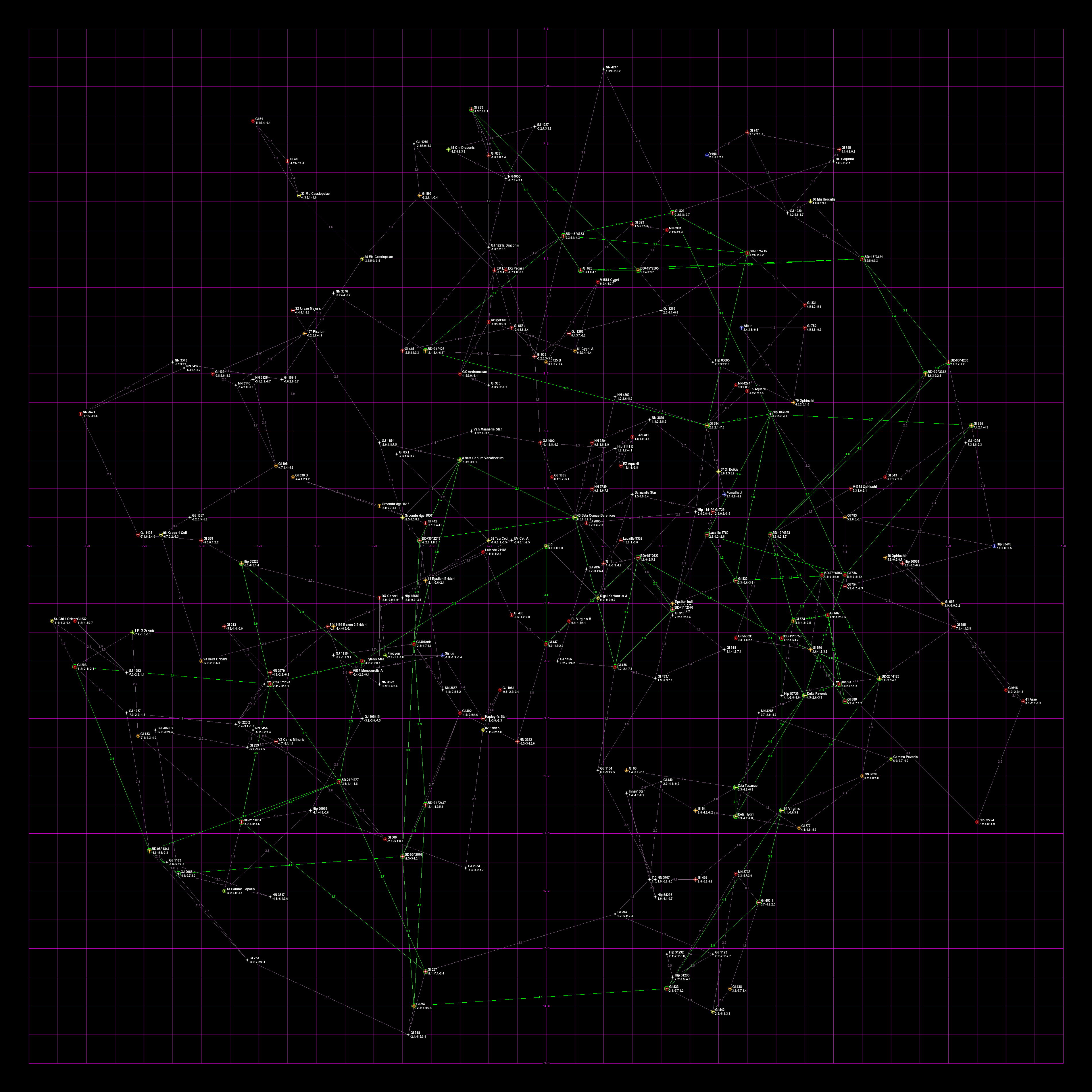
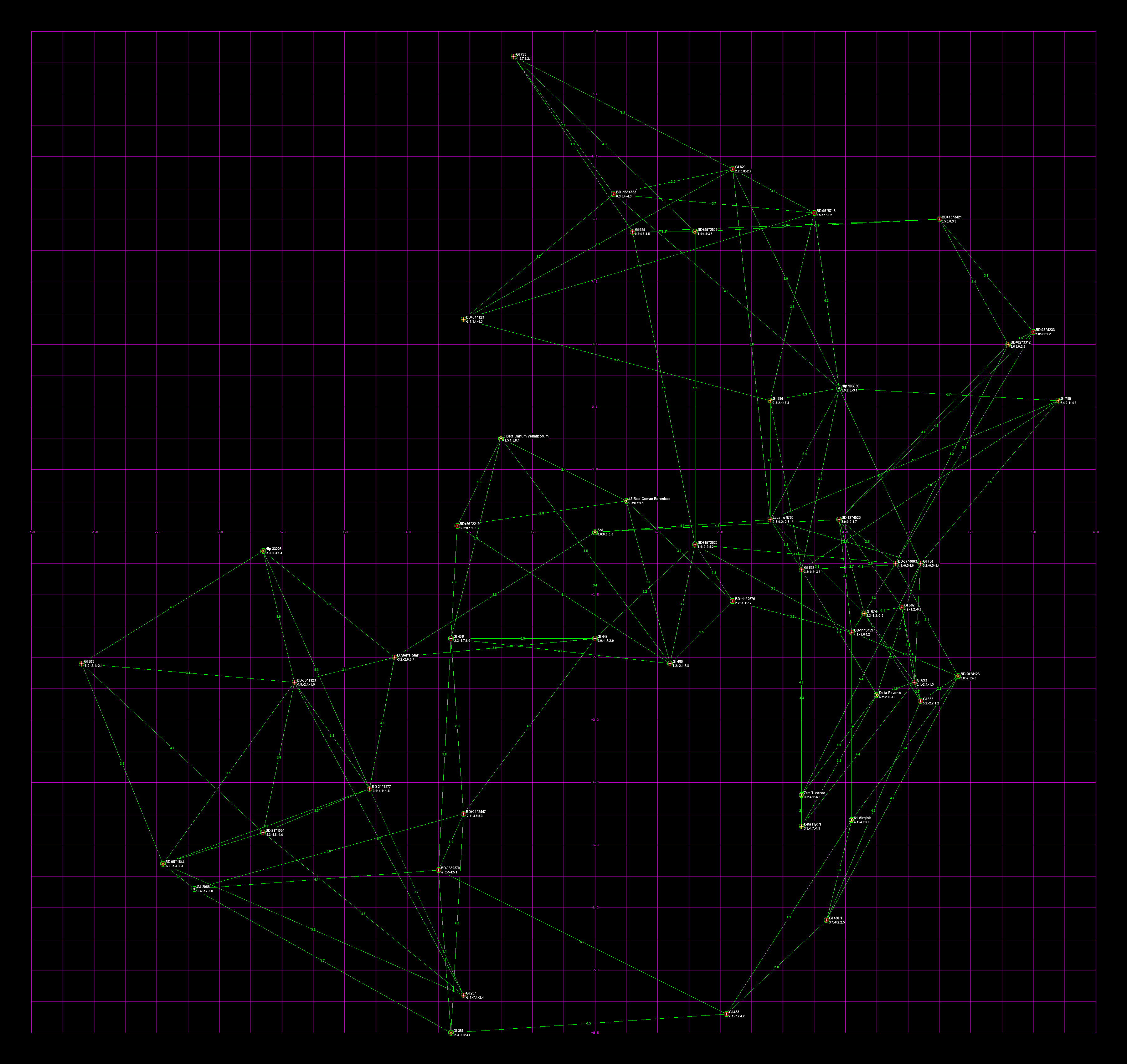
Winchell's HabHYG Starmaps
The following are based on the HabHYG dataset (i.e., they are as up to date as I can make them). I hereby grant permission for anybody to freely use these maps or lists in their novels, games, or projects. Acknowledging this website as the source would be nice but I do not insist upon it. The main thing is to get accurate 3-d starmaps in wider circulation. Note that the maps are automatically generated by software, not by hand, so sections of the maps are a tangled mess.
Galactic co-ords, galactic core is in the direction of the +X axis, -X is rimward, +Y is spinward, and -Y is trailing. All units are in parsecs (again: multiply parsecs by 3.26 to get light-years). Stars likely to possess habitable planets are circled in green. Each habitable star has green lines linking them with the closest two habitable stars. Line are labeled with the distance in parsecs. On the maps with non-habitable stars, in addition each non-habitable star has purple lines linking them with the closest two stars. These lines are just to give one a feel for a star's neighbors. If all the lines were drawn the map would resemble a cobweb made by a spider on LSD.
Also included are versions of the map in node or 2½-D format. Remember, lines are only included for a star's two closest neighbors. Different maps would result with different line rules (e.g., a neighbor stars within distance X, single closest neighbor, stars with similar masses, lines joining all stars except where intervening stars too close to the line choke it off, etc.). The *.gml files have also been included in case you wish to move the nodes around yourself. These files can be used with the yEd software discussed in the 2½-D section.
The gif maps were drawn with my crude program StereoStar. I included the *.str files used by StereoStar. Warning, the program is crude and very buggy. Use at your own risk.
The line lists are simple text files with the start and end points of each line.
The star spreadsheets are in comma separated format.
| Column | Value | Notes |
|---|---|---|
| 1 | HabHYG index number | |
| 2 | Hipparcos catalog number | |
| 3 | Habitability flag | 1 = star has a high probability of hosting a human habitable planet (i.e., it is listed in the HabCat database). |
| 4 | Name on map | (i.e., the most colorful name out of all the possibilities, in my opinion). |
| 5 | HYG catalog number | |
| 6 | Bayer-Flamsteed name | Numbers and greek letters are alternate prefixes (e.g., "18 Epsilon Eridani" can be called either "18 Eridani" or "Epsilon Eridani"). |
| 7 | Gliese catalog number | |
| 8 | Bonner Durchmunsterung catalog number | (Used by James Blish in his "Cities in Flight" novels) |
| 9 | Henry Draper catalog number | |
| 10 | Hoffleit Bright Star catalog number | |
| 11 | Star's proper name | May not exist |
| 12 | Spectral class | |
| 13 | Distance from Sol | In parsecs. |
| 14, 15, 16 | xyz galactic cartesian co-ordinates | In parsecs (used to draw the maps) |
| 17 | Star's absolute magnitude. |
Maps

All stars within 15 light years of Sol (52 total). 
Node map of stars within 15 light years of Sol. 
All stars within 20 light years of Sol (111 total). 
Node map of stars within 20 light years of Sol. 
All habitable stars within 20 light years of Sol (17 total). 
Node map of habitable stars within 20 light years of Sol. 
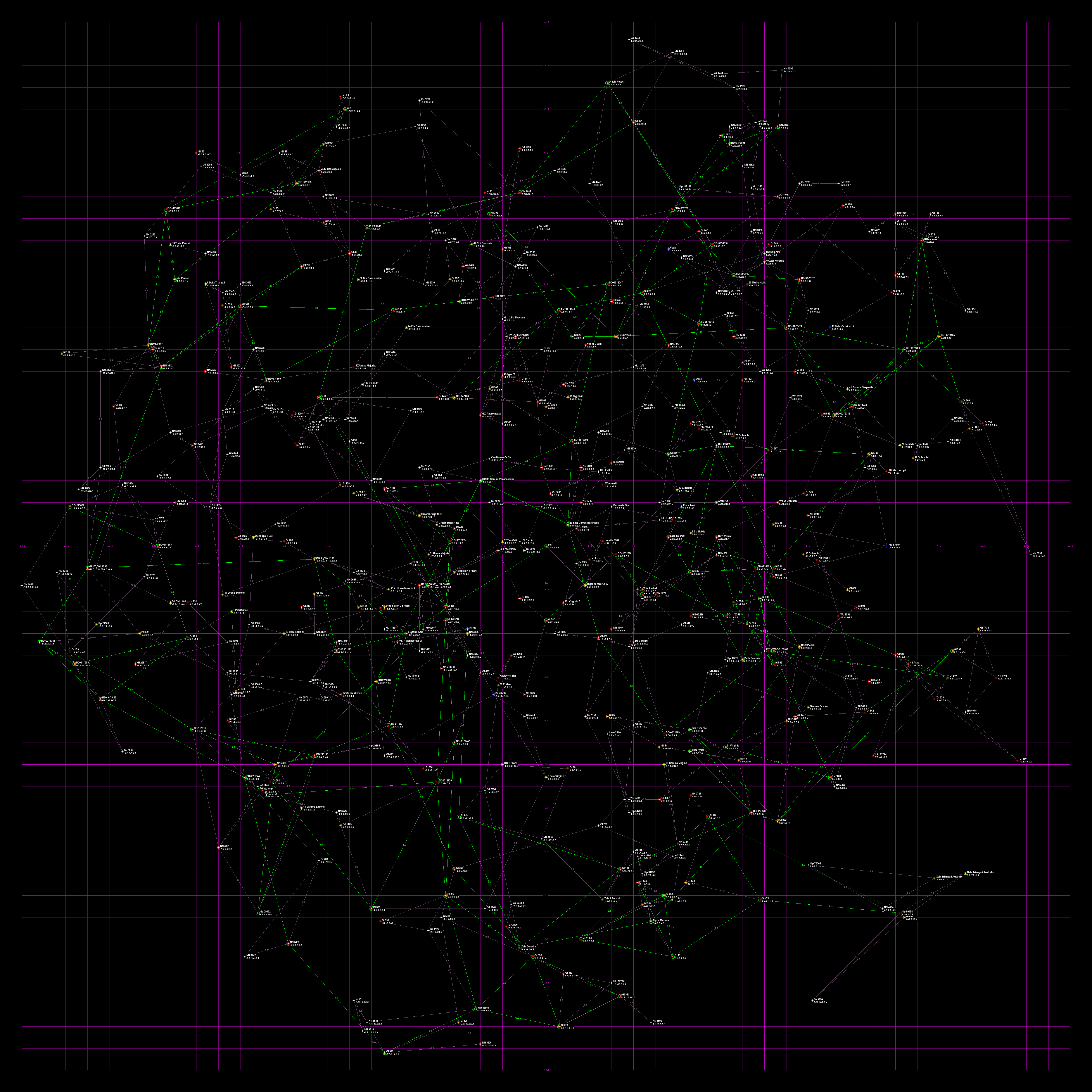
All stars within 30 light years of Sol (277 total). This map is on the verge of unusable due to the confusion of lines and stars. 
Node map of stars within 30 light years of Sol. 
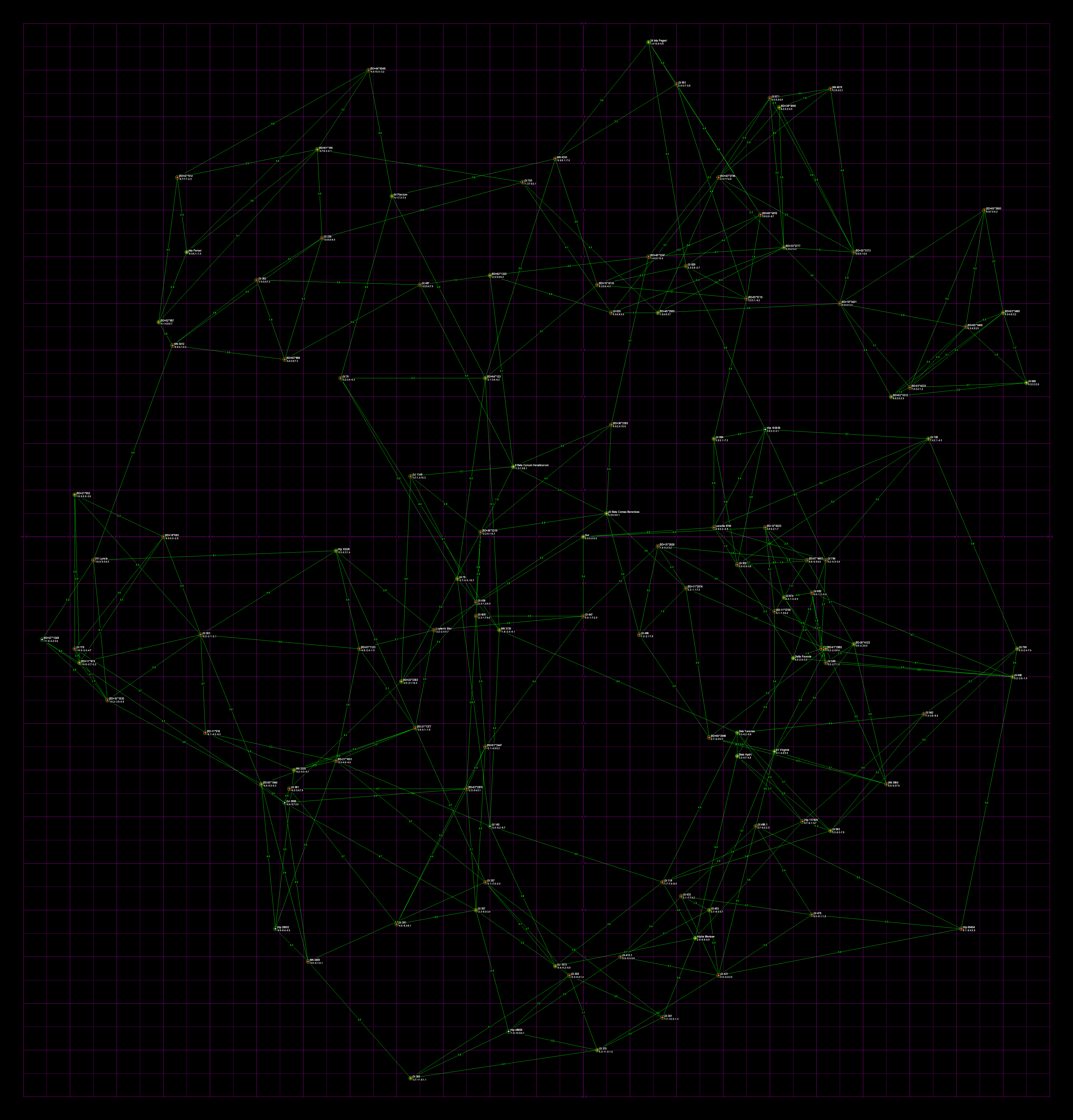
All habitable stars within 30 light years of Sol (51 total). 
Node map of habitable stars within 30 light years of Sol. Note that the habitable stars seem to be in two clusters, with a link between GL 433 and GL 357 near the middle. If the Empire of Sol was expanding at the same time as the Blortch Imperium of Zeta Tucanae, that link will probably be the site of first contact, and the start of the First Interstellar War. 
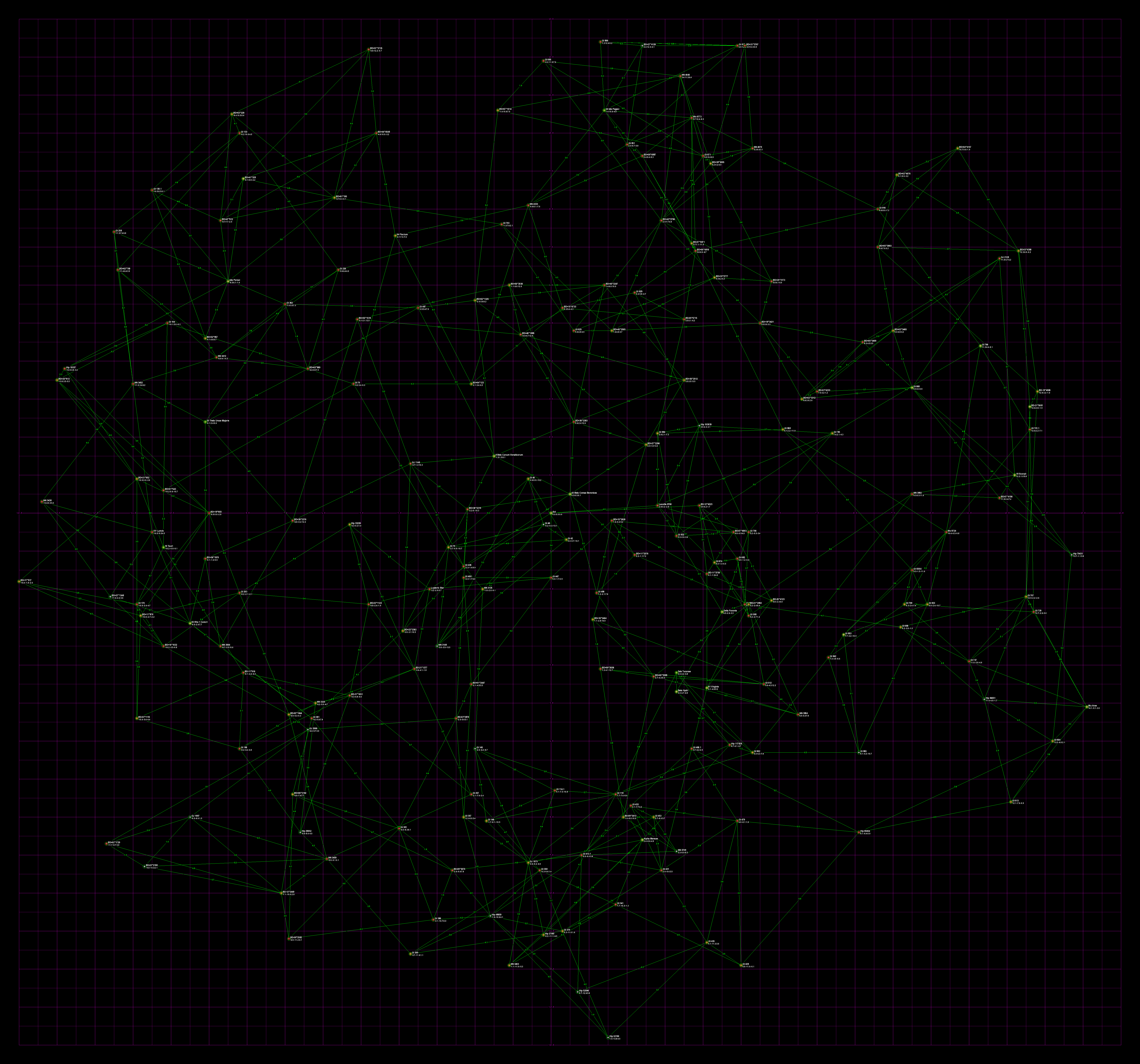
All stars within 40 light years of Sol (572 total). This map is pretty unusable due to the confusion of lines and stars. 
All habitable stars within 40 light years of Sol (121 total). 
All stars within 50 light years of Sol (998 total). This map is utterly unusable due to the confusion of lines and stars. 
All habitable stars within 50 light years of Sol (211 total). This map is on the verge of unusable due to the confusion of lines and stars.


Interstellar Empire Framework

Here's the result of my experimental Interstellar Empire Framework project.
I started with one empire centered on Sol. For the dreaded center of the evil Zork Empire, I looked at the HabCat database and arbitrarily picked a star that was 150 light-years away from Sol: BD-09°431. The locations of the two empire centers was averaged to locate the point exactly midway between.
The map is going to encompass a capsule shaped volume, that is, a cylinder with both ends capped by hemispheres. This will represent two 60 light-year diameter spheres (30 light-year radius), one centered on Sol, the other on Zork Prime. The rest will be in a cylinder 30 light-years in radius connecting the two spheres.
The 60 light-year diameter spheres will be the "spheres of influence" of Sol and Zork. Another 60 ly diameter sphere centered on the midpoint will be the Neutral Zone. The idea is that the intrepid empire builder will decide which stars have been explored, which have mining colonies, which are colonized, and which are officially part of the empire. Once the enemy has been discovered, the neutral zone will alternate between being a demilitarized zone and the main battle line. As previously mentioned, this will be populated by spies, smugglers, covert battlefleets intent on causing boarder incidents, and planets named "Casablanca".
So I wrote a quick Python program and fed it a subset of the HabHYG database. It filtered out all the stars outside of the capsule volume and generated lines between each star and its closest two neighbors. Stars inside the two spheres of influence and the neutral zone were color coded. The program outputted this data as a GML format node map.
I then opened the file in yEd, autoformatted it, then laboriously tweeked it until it was compact. I saved it as a GIF file, and as a WMF file. I then used Adobe Illustrator to tranform the WMF file into a PDF file.
Here are:
Have fun with it.
The rest of the starmaps
- Astrocartics Lab
- They have created a new map for sale. The map is of all known stars within 12.5 light-years of Sol. It also displays notable stars within 25 light years including all stars with a mass greater than 0.65 of the Sun as well as all confirmed planets. The map uses an innovative way to display three dimensions on a flat map in a clear manner.
- Galaxy Map
- Probably the most comprehensive and accurate map of the entire galaxy anywhere.
- Extrasolar.net
- A very impressive Flash 3D map of the local stellar neighborhood. It has diagrams of the known extrasolar planets, and extensive search facilities.
- Astrogator's Handbook
- A must-have three dimensional star atlas for all your stellar cartography needs. The standard edition includes 300 stars inside a fifty light year cube centered on Sol, and is a free PDF download. The expanded edition includes 3,500 stars inside a 150 light year cube centered on Sol. The expanded edition cost range from $15 to $50, depending on the version (pdf, printed notebook black-and-white, printed notebook glossy color).
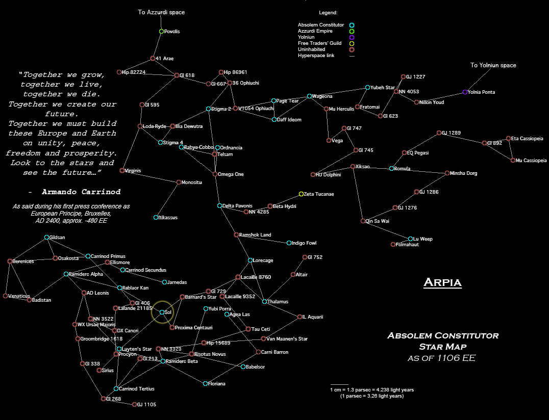
- Arpia
- A map of the Arpia universe, created by Peter Craddock. The map is based on the HabCat dataset. This will be for a series of novels based on his plug-in for space-based game "Escape Velocity: Nova".
- Star Map Outreach Project
- Instructions on how to make your very own do-it-yourself starmap using foam core, wire, and pins. The map is 10 centimeters square and includes the 15 closest known stars to Sol. Courtesy of the NASA Institute for Advanced Concepts
- Outsider
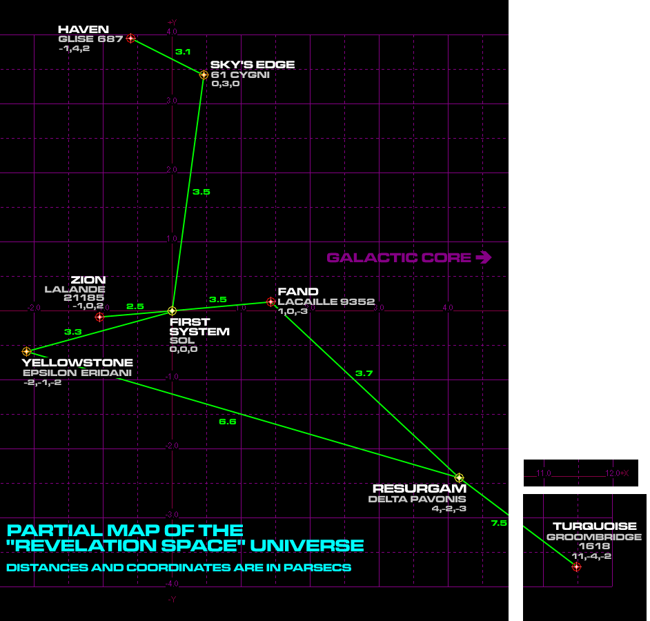
- Revelation Space
- An unofficial map by yours truely of the Revelation Space novels by Alastair Reynolds.
- Strategic Space Command Stellar Cartography
- various 3-D maps made by the author for the starship Leif Ericson.
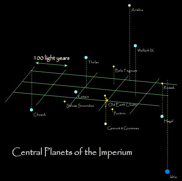
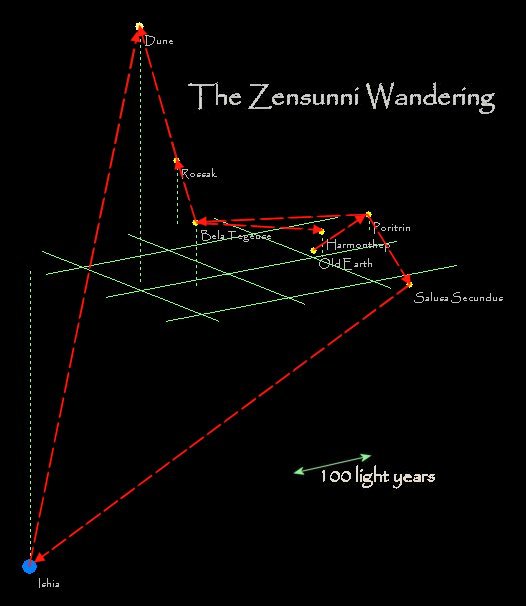
- Andrew Hobson's DUNE starmaps
- Andrew Hobson has crafted some nice starmaps of the universe of the Dune novels of Frank Herbert. The Central Planets. The region around Old Earth. A map of the Zensunni Wandering. He also has the star data in an Excel Spreadsheet, based upon the work of Joseph Daniels.
- It's Full Of Stars!
- Lots of maps created by Claus Børnich's It's Full Of Stars software.
- Lähiavaruuttamme
- Stunning rendered 3-D starmaps by Tero Niemi. There is also a handy datafile of the Gliese catalog pre-processed for your use. See more of his work here.
- ana3.png
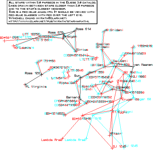
- 3-D anaglyphic starmap all stars within 5 parsecs. Equatorial projection. Gliese 3.0 data. Lines draw between stars closer than 2 parsecsYou will need red-blue anaglyphic glasses, which are available here. Winchell Chung
- gliese2in7parsecs.png
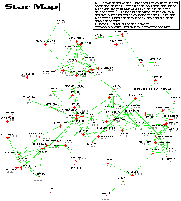
- 3-D starmap all stars within 7 parsecs. Galactic projection. Gliese 2.0 data. Lines draw between stars closer than 1 parsec. Winchell Chung
- Full Thrust Stellar Cartography
- various 3-D maps made by the author for the starship combat game Full Thrust.
- Jed Whitten's online starmap
- A most impressive online configurable starmap using David Nash's HYG Database
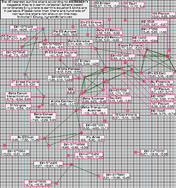
- 46nearsuns.png
- 3-D starmap of the 46 closest sunlike stars. Equatorial projection. Winchell Chung
- 3-D Mapping of the Local Interstellar Medium
- Accurate galactic maps from THE GUIDE TO THE GALAXY
- Near Star Map
- 3-D starmap all stars within 26 light years. Galactic projection. Nelson Cunnington. Nelson is a professional, but impoverished, graphic designer and so will not draw maps to order for nothing, so please don't ask. He is, however, gloriously egomaniacal, so please feel free to email him at nelson At aguchi.demon.co.uk to praise for his map.
- m15.gif
- 3-D starmap of all stars within 15 light years. Galactic projection.
- Parallax Examples
- 3-D stereograms of various locations. Scroll down to see the images.
- Starmap.gif
- StarForce style 20 LY starmap by Hartley Patterson
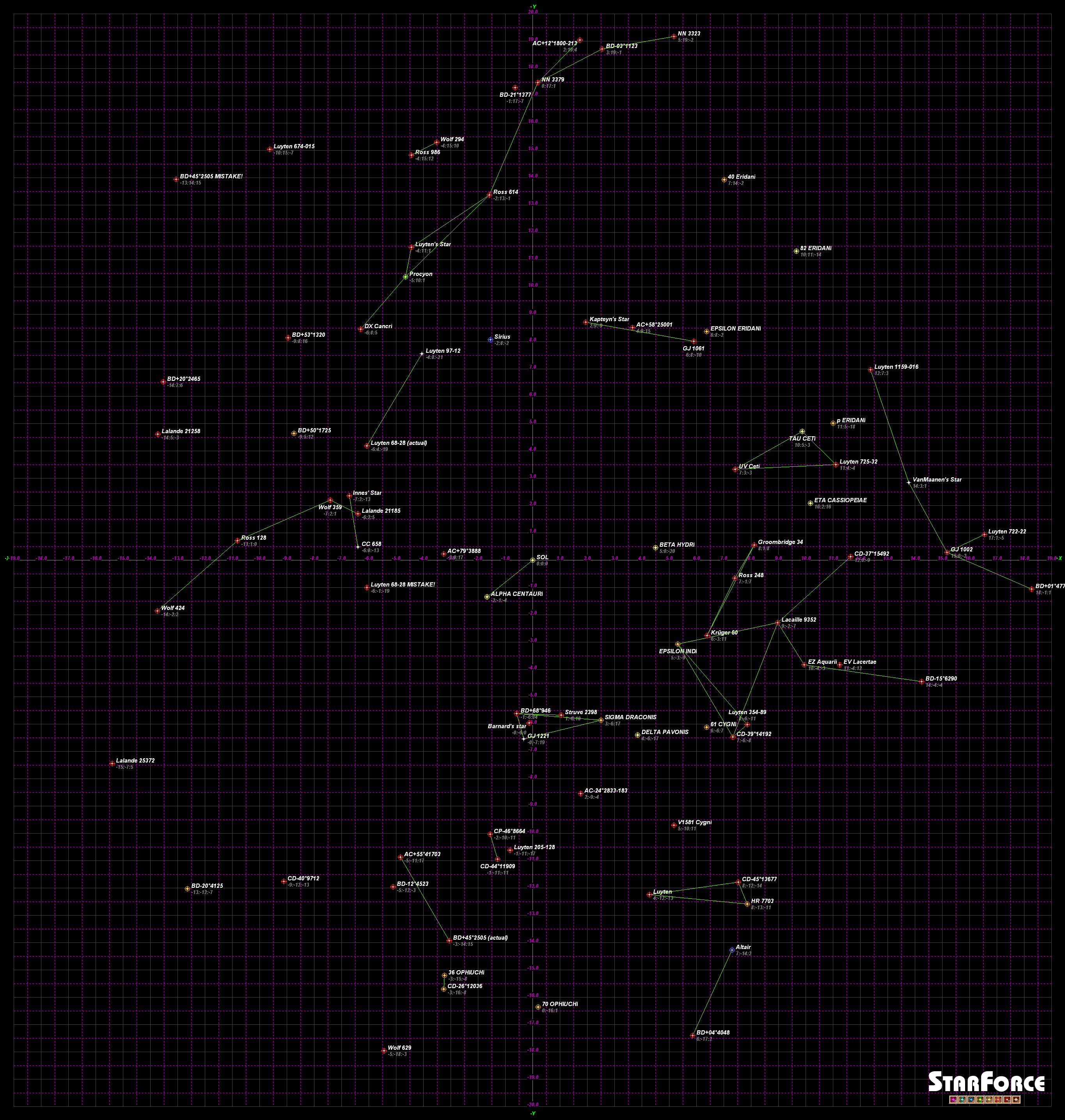
- StarForceMap.png
- StarForce map in cartesian co-ords by Winchell Chung
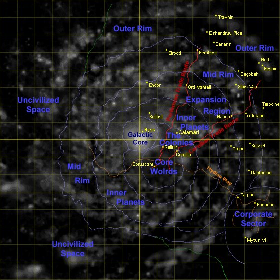
- starwars_galaxy1.jpg
- Map of the Star Wars galaxy.
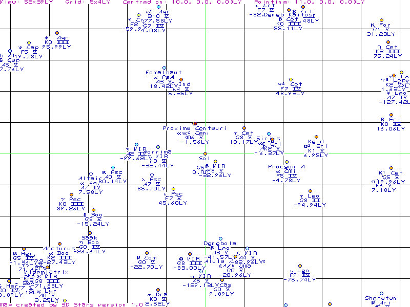
- 3D Stars Sample
- This is a sample map Thomas York created with his program 3D Stars . Here's what he has to say about it:

This is a sample map from 3D Stars, a program that allows you to move through the local stellar neighbourhood in 3D and create images of it. This map is a parallel projection onto a plane 52 by 39 lightyears in size, centred on the sun. The plane is facing the constellation Pisces (for those who know, that's RA:0h 0m 0s and Dec:+0 0m 0s). All the stars on the map have Bayer letters (alpha, beta, gamma etc) and are brighter than about magnitude 6 (absolute). The full program allows any position/direction planes to be used.
Thomas D. York 
- An Atlas of the Universe
- A good series of maps on ever increasing scales.
- Anders Sandberg maps of the Orion Arm
- Some good maps on ever increasing scales, plus a Java Applet
- Maps of Human Space
- Maps from the Traveller 2300 RPG
- Star Trek Stellar Cartography
- This has more than just Star Trek related material. There is valuable astronomical material based on reality.
- Star Trek Arena

